
About this Tool
Projection Wizard is a web application that helps cartographers select an appropriate projection for their map. Depending on the extent and the distortion property of the map, the application returns a list of proposed map projections with additional projection parameters if necessary. There are PROJ and WKT links next to each projection that open a popup window with a PROJ or Well-Known Text string available for copying to the clipboard. Both strings are used in many cartographic and GIS applications. Projection Wizard displays a map preview on the right side of the list with a suggested projection. The preview shows how the projected data will look using D3.
This tool is based on John P. Snyder’s selection guideline and on the extension to this guideline for world and hemisphere maps written by the Cartography and Geovisualization Group at Oregon State University. Projection Wizard v2.0 also takes into account the results of a study published by Šavrič et al. in 2015. All publications related to Projection Wizard are listed at the bottom of this page.
When you publish a scholarly article that uses Projection Wizard or discusses its functionality, you are kindly asked to cite the following article: Šavrič, B., Jenny, B. and Jenny, H. (2016). Projection Wizard – An online map projection selection tool. The Cartographic Journal, 53–2, p. 177–185. Doi: 10.1080/00087041.2015.1131938.
How to Use this Tool?
Using Projection Wizard is easy and requires only two steps:
1 From the radio button list, select the distortion property of the map.
2 Select the geographic extent by using the input boxes on the left side of the map or by changing the rectangle on the map.
The anchors at the corners of the rectangle allow it to be resized. The rectangle can also be dragged around the map. Any change to the rectangle is reflected in the input boxes and vice versa. Changes to the rectangle or distortion property interactively update the list of proposed map projections and the map preview below the web map.
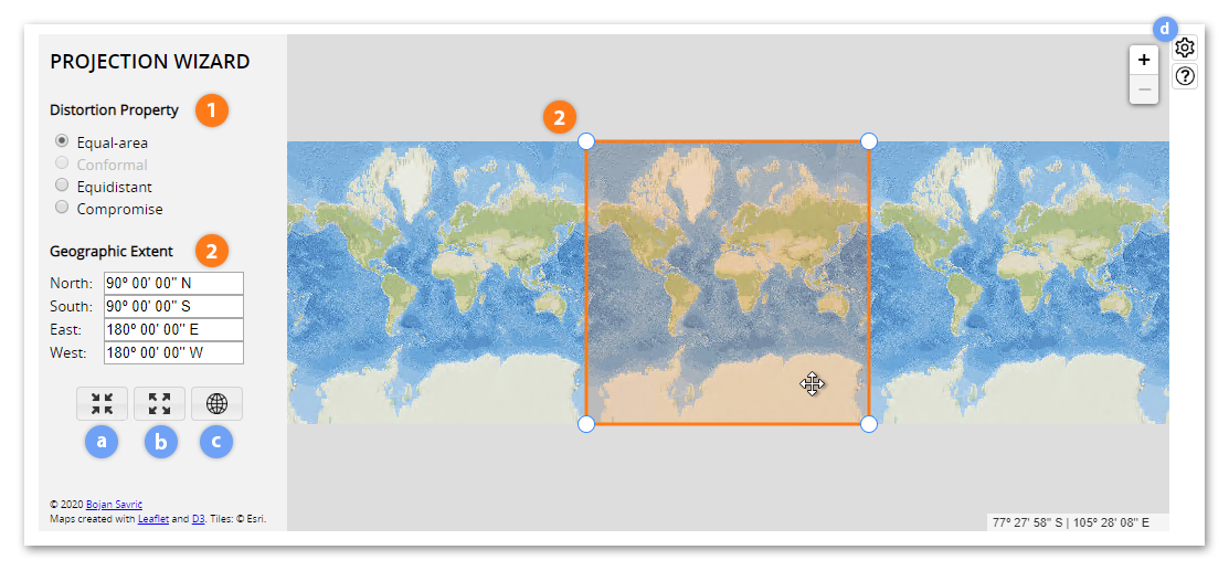
a The Select Currently Visible Area button adjusts the rectangle size to the current map view, selecting approximately 80% of the visible map.
b The Select Entire World button sets the rectangle size to the full extent.
c The Show Entire World button zooms out to the full extent.
d The Customize button opens the Projection Wizard Options dialog, which allows the user to modify the tool.
Customizing this Tool
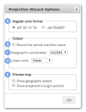
The Projection Wizard Options dialog allows you to modify the tool to better fit your needs. The options affect the projection parameters, elements in the PROJ and WKT strings, and the map preview. You can:
A toggle between decimal degrees and DMS formats for angular units,
B round the central meridian value to the nearest degree,
C select a system of geographic coordinates for the output strings,
D select between meters and international feet for linear units in the strings, and
E display the selected extent and/or the projection's origin point(s) in the map preview.
Selection Criteria Derived from the Geographic Extent
The extent of the geographic area:
World map – shows at least two-thirds of the full extent
Map showing a hemisphere – shows between one-sixth and two-thirds of the full extent
Map showing a continent or smaller areas – shows less than one-sixth of the full extent
The predominant extent and the orientation of the area shown on the map:
An east-west extent, resulting in a landscape-oriented map – the ratio between the central meridian and the longest parallel lengths is less than 0.8
A north-south extent, resulting in a portrait-oriented map – the ratio between the central meridian and the longest parallel lengths is more than 1.25
An equal extent, resulting in a square-shaped map – other ratio values
The latitude of the mapped area of a square-shaped map:
Center at pole – the central latitude is more than 75º N or 75º S
Center along equator – the central latitude is between 15º N and 15º S
Center away from pole or equator – all other central latitude values
The latitude of the mapped area of a landscape-oriented map:
Center at pole – the central latitude is more than 70º N or 70º S, or geographic area in a conic projection would otherwise expose an opening at a pole.
Center along equator – the central latitude is between 15º N and 15º S, or geographic area is within 23.43665º N and 23.43665º S for maps showing a hemisphere.
Center away from pole or equator – all other central latitude values
Additional Notes and Tips
For world maps:
- Conformal projections are not useful for world maps because they deform the shapes of the continents in a way that map readers are not used to seeing.
- Rectangular projections are not generally recommended for most world maps. However, there are some rare phenomena based on longitude that are best represented by a map with straight meridians, such as a map showing world time zones.
- Small-scale world maps usually represent the world over a continuous space without interruptions. When cartographers map only land phenomena or only ocean phenomena, an interrupted projection is a possible choice. Interruption can be applied to most equal-area and compromise world map projections. Depending on the purpose of the map (i.e., whether showing land or ocean), the locations of intersections and central meridians are adjusted.
For maps showing a hemisphere:
- Conformal projections are not useful for hemisphere maps since they grossly distort shape and area along the border of the projected hemisphere. Preserving angles is rarely needed for hemisphere maps.
For maps showing a continent or smaller areas:
- Compromise projections are not useful for maps showing a continent or a smaller area.
- To reduce overall area distortion for the conformal projections, one can also apply a scale factor k. Various values for k are applied and the area distortion patterns along the center and at the border of the map are compared.
- To reduce overall distortion for the equal-area projections (not for the azimuthal projections), one can also compress the map in the north-south direction (with a factor s) and expand the map in the east-west direction (with a factor 1 / s). The factor s can be determined with a trial-and-error approach, comparing the distortion patterns along the center and at the border of the map.
- In some rare cases, it is useful to retain scale along great circles in regional and large-scale maps. Map readers can make precise measurements along these lines that retain scale. It is important to remember that no projection is able to correctly display all distances and that only some distances are retained correctly by these "equidistant" projections.
- When mapping a specific country or state, the cartographer can also use the state's official projection. Often this projection not only minimizes the distortion of the mapped area, but it may also simplify the cartographer's work. A majority of the state's base data is available with the official projection. Most countries use a conformal projection for their official large-scale maps, which is preferred for surveying, navigation, and military use. One can search for official projections by area of interest in the EPSG Geodetic Parameter Registry.
Update History
Projection Wizard 2.0 (June, 2020)
- The extent of the geographic area is determined based on spherical surface equations.
- The predominant extent is computed with the ratio between the central meridian and the longest parallel lengths on a sphere.
- Updated criteria for the latitude of the mapped area of a landscape-oriented map.
- Projection for showing the tropics category was added for hemisphere maps when geographic area is within 23.43665º N and 23.43665º S.
- Additional suggestions were added to the list of appropriate map projections for the conformal property at very large map scales.
- The Cassini projection was added to the list of appropriate map projections for the equdistant property and portrait-oriented maps.
- The Plate Carrée projection was replaced with the equdistant cylindrical for a landscape-oriented map and geographic area along the equator.
- The Equal Earth projection was added to the list of equal-area world map projections.
- Projections that excessively bulge outwards and interrupted projections were removed from the world lists.
- The list of world equidistant projections is now given as a dropdown menu. For each projection in the menu, sliders (and radio buttons) were added next to the parameters, so user can now adjust arbitrary points.
- Preview map updates were added when a user hovers over projection's name with the cursor on the world lists.
- The preview map is now clipped to the exact geographic area selected by a user.
- Projection parameters for world projection are now rounded to entire degrees, to half degrees, and to tenths of degrees depending on the size of the selected geographic area.
- Projection parameters for maps showing a hemisphere and the tropics are now rounded to two decimal places.
- PROJ string values were rounded to a maximum of seven decimal places and datum or ellipsoid information and linear unit were added to the string.
- WKT strings are provided for each proposed projection.
- A Customize button was added, which opens the Projection Wizard Options dialog. Users can now toggle between decimal degrees and DMS formats for angular units, round the central meridian value to the nearest degree, specify the geographic coordinate type for their output strings, select between meters and international feet for linear units, and display the geographic extent and the projection's origin point(s) in the map preview.
- Continuous updates to the output, preview map, and extent inputs have been added during individual vertex or whole rectangle dragging.
- The user interface, popup windows, preview maps, third-party libraries, and help content were updated.
This update was prepared in collaboration with @jwasilgeo and @jgravois.
Projection Wizard 1.2 (May, 2017)
- PROJ code was fixed for the Lambert azimuthal projection.
- The help content was updated.
Projection Wizard 1.1.1 (February, 2016)
- The help content was updated.
- A list of publications and related articles about Projection Wizard was added.
Projection Wizard 1.1 (December, 2015)
- The Patterson projection was added to the list of compromise world map projections.
- The help content was updated.
Projection Wizard 1.0 (October, 2014)
- Map preview added to the list of appropriate map projections.
- Selection criteria for a hemisphere map updated on one-sixth of the full geographic extent.
- Updated criteria for the latitude of the mapped area of a landscape-oriented map. The map has a center at pole when the central latitude is more than 70º N or 70º S, or more than 67.5º N or 67.5º S for showing between one sixth and one eighth of the full geographic extent.
Map Projection Selection Tool (June, 2013)
- Original web application
Publications and Related Articles
Jenny, B., Šavrič, B., Arnold, N. D., Marston, B. E. and Preppernau, C. A. (2017). A guide to selecting map projections for world and hemisphere maps. In: M. Lapaine and E. L. Usery (eds), Choosing a Map Projection, Lecture Notes in Geoinformation and Cartography (pp. 213–228). Berlin, Heidelberg, New York: Springer. Doi: 10.1007/978-3-319-51835-0_9
Šavrič, B., Jenny, B. and Jenny, H. (2016). Projection Wizard – An online map projection selection tool. The Cartographic Journal, 53–2, p. 177–185. Doi: 10.1080/00087041.2015.1131938
Šavrič, B. (2016). Projection Wizard: A free web application for selecting a map projection. ISPRS SC Newsletter, 9–4. p. 5. Available online: http://www.isprs-sc.org/material/isprs_sc_vol9_no4.pdf
Šavrič, B., Jenny, B., White, D. and Strebe D. R. (2015). User preferences for world map projections. Cartography and Geographic Information Science, 42–5, p. 398–409. Doi: 10.1080/15230406.2015.1014425
Šavrič, B., Jenny, B. and Jenny, H. (2014). Map projection selection tool. Presentation at the 34th Annual Meeting NACIS 2014, Pittsburgh, Pennsylvania, October 8–11.
Snyder, J. P. (1987). Map Projections – A Working Manual. Professional Paper 1395. Washington, DC: US Geological Survey. Doi: 10.3133/pp1395
Featured by GIS Lounge and Maps Mania.